The Story Behind Mississauga’s Indian Road
/
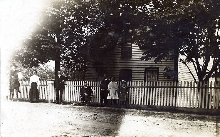
Putting Through Indian Road, 1917, photo from Margaret Denison
What we know today as Indian Road was not, in its origins, a planned thoroughfare, but its roots do connect back to some early surveys in historic Mississauga.
Part of the route of Indian Road today, running roughly southeast from the South Service Road to Woodeden Drive, follows a survey division line between the Old Survey of Toronto Township and the lands set aside in Treaty 14 as the Credit Indian Reserve, as surveyed in 1806. Coming from the opposite direction, running westward today from Mississauga Road to Woodeden Drive, modern Indian Road follows the division line between Ranges 1 and 2 of the Credit Indian Reserve, as surveyed in 1846. Lands within the Credit Indian Reserve were put up for auction by The Crown for settlement purposes in 1847, following the departure of the Credit River Mississaugas.
The area south of the Middle Road, starting roughly where Indian Road today runs southeast off of the South Service Road, was the first part to be opened and subdivided. Two formal plans for subdivision were registered in 1913. The first, by F.R. Jarvis as Plan F-13 (registered May 5, 1913), and the second, by George Perry as Plan H-13 (registered July 9, 1913) made use of the right-of-way that would become Indian Road. The part of Indian Road was indicated on these early subdivision maps, but they do not show a road name. The first stretch of road only connected to Lorne Park Road, a really functioned as an extension of the earlier Lorne Park Road – and as such may have carried that name association. By 1914 what would become Indian Road, following the old survey line, extended past Lorne Park Road to what is Oak Lane, but no farther. The topography halted its course.

Wilmot's 1806 survey plan - Old Survey, Toronto Township - portion of Indian Road alignment marked in Red
Westward from Mississauga Road, by 1914 Indian Road had not yet been put through. There were the beginnings of a rough trail, which ran west of Mississauga Road and was referred to as “Kelly’s Road”. This stretch of road led to the Madigan and Kelly farms, and to the rear of a Denison family farm – another early laneway, Madigan’s Lane, can still be found, running north off of Indian Road.
Kelly’s Road petered out into a heavily wooded area and steep ravine (near what is today Woodeden Road). There was an earlier access lane running south off of the Middle Road (now the QEW), but it did not connect with what was Kelly’s Road due to challenging topography. This laneway would come to be called Indian Grove Avenue (later renamed to Indian Grove) once this area began to be subdivided in 1917 under Plan B-17 by Edgar Stephens.
In 1915 there was a move to extend Kelly’s Road and a petition was brought to Toronto Township Council. In 1916 a survey team was brought in to chart the route for the planned extension and Township Council then authorized the sale of timber along the intended course for the extension.
Madigan Family, Mississauga Road, c1900, courtesy of Mississauga Library System
As referenced in Verna Mae Weeks’ book “Lorne Park: Dreams of Long Ago” (1993), a letter sent to Council by Cecil Denison on October 4, 1917, highlighted the desire to improve Kelly’s Road. Denison and several neighbours offered their services to improve the road, and work began in the spring of 1917. As recounted in Weeks’ book: “Frank Shaver recalls today that Cecil Denison was the foreman for the job, and that they had four teams of horses. Frank Shaver drove the team with the scraper, George Shaver drove another team, and they also had two other drivers from the neighbouring farms. The gullies had to be filled in, for at places the stream flowed over the road allowance. The earth had to be scraped up and the ground levelled, but the job was done. In this manner the Indian Road was put through, by the people of the area.” The biggest obstacle to overcome was the hill near what is today Woodeden Drive – what locals referred to as Denison’s Hill. The hill was partially cut down to put the road through. By 1919 the two sections of road were finally connected, creating the through road we know today as Indian Road.

Former Kelly farmhouse, 1989
But what about the name itself? From local references, it appears that reference to “Indian Line” and “Indian Road” were in use, at least informally, as early as 1914, but applied to the western section of the right-of-way. It is quite possibly, maybe even likely, that the origin of the reference is even earlier and may connect back to the 1806 survey and the “angled” lot alignment in connection with the aforementioned Credit Indian Reserve – this line marking the western side of the 1-mile border from the Credit River as affirmed in Treaty 14. As such, the origins may be a simple as a reference to the border or survey lines connected to the Credit Indian Reserve or simply the “Indian Line”. When Kelly’s Road and Indian Road were finally connected in 1918-1919, the name Kelly’s Road faded from use. We have not found, as of yet, a formal recognition or date for the naming of the road as “Indian Road”, although by 1925 it appears to carry the name for its entire route.
We recognize that the term Indian is inappropriate today, but it our hope that by examining the evolution of the road and the likely origins of its name, that we can place the road into the context of its time, and also highlight its connection, even as a border marker, to the former Credit Indian Reserve lands and the history of the Indigenous Mississaugas of the Credit River.