The history of Mississauga Road - a journey through time
/Meandering along Mississauga Road today, one can catch glimpses into several layers of history; the journey along Mississauga Road is in part a journey through time. The road shares a story that is akin to that of the Credit River – just as the river meanders through Mississauga, Mississauga Road follows the course of the river closely as it traverses our city from Lake Ontario to our Northern border. Both the river and Mississauga Road were once vital lifelines and routes of transportation in the early years of settlement, their quiet and occasionally rural ambience obscuring their importance to early life in what would become the City of Mississauga. The story of Mississauga Road has many chapters, and only a few that will be touched on with this article.
Harris family travelling along Mississauga Road, c1900
First, let’s start with the route itself; much of Mississauga Road, south of modern Eglinton Avenue, is believed to follow an Indigenous trail that hugged the high ground above the flood plains along the course of the Credit River. The route itself deviates from the traditional cadastral survey favoured by land surveyors, and as such much of its course is a given road – that is, a route that is accepted and travelled but does not, in parts, conform to the survey. This is visually evident from the southern section of the road, south of Dundas Street.
North of Eglinton Avenue, Mississauga Road follows the established survey into Streetsville. The road was planked in the 1850s, became a corduroy road in the 1860s, and was macadamized and layered with gravel (referred to as “stone”) in the 1890s. When it was first paved, in the 1950s, evidence of the early wooden planks were found under the gravel. Perhaps some of these remnants, or remnants of stump fences, remain buried under the modern road we travel on today.
Bickell-Rosen Estate - Arcadia
Along its route, modern Mississauga Road passes by former inns and stagecoach stops dating to the 1830s and 1840s; large estates dating from the early 1900s; stone walls which hint at a landscape, and a land use, from the past; humble family dwellings and homesteads dating to the early 1850s; a relocated log house; remnant farm properties that remind us of our not-to-distant agricultural and fruit growing roots; the site of the former Credit Mission Village; a venerable stone church that overlooks the intersection of the Credit River, Mississauga Road and Dundas Street; an old school and the modern University – all are dotted along the course of Mississauga Road, harkening to several layers of history in a single pass.
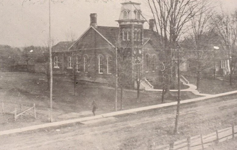
Erindale - Erindale Public School, c1924
Although the date of the official adoption of its modern name is not certain, in the past, sections of Mississauga Road carried other names. These names included: Swamp Road, Cedar Swamp Road, Coldspring Road, Spring Road, Springbank Road, Springfield Road, Indian Village Road, Stone Road, Streetsville Plank Road, and the Streetsville Stone Road – likely amongst others. The name of the road as “Mississauga Road” predates the naming of our city.
Oughtred's Market, Erindale
As you travel along Mississauga Road, one passes through areas that were also once known to locals by other descriptive names such as IALFA, Oakridge, Arcadia, Glades of Fleet, Ross’ Hill, Maple Hill, Windy Hollow, Springbank, Sawmill Hill, Stonehouse and Rogers’ Road, amongst many others. What is the story of the names? Some other early settler families are commemorated in modern street names which intersect with Mississauga Road: Harkiss Road, Featherston Drive and O’Neil Gate, amongst others. Many of these early settler families are buried in the two historic cemeteries behind St. Peter’s Anglican Church at the corner of Mississauga Road and Dundas Street West, as are several veterans from the War of 1812 and a British officer from the Napoleonic wars. And long before them, the Indigenous Mississaugas knew the path. The route has old roots indeed!
As we travel along Mississauga Road today, we are, without a doubt, travelling in the footsteps (and wagon wheels) of those who have come before us – including the Rebel Leader William Lyon Mackenzie who traversed down the course of Mississauga Road when fleeing from authorities following the Rebellion of 1837!
Oneida Country Club, formerly IALFA
Mississauga Road invites questions as well. Can you find the stone pineapples? Who was Richard DeBoo and what was the Oneida Country Club? Do you remember the cold, clear water of the spring, or ice cream from Oughtred’s Market? Was there a sawmill on Sawmill Creek? Have you heard the sad story of Abednego Patchett? What is the story of the Anderson Estate and the “castle”? Mississauga Road becomes Queen Street through Streetsville, or more correctly, Queen Street, which was named first, becomes Mississauga Road outside of the village proper. But who was the Queen?
There truly are fascinating stories to ponder and wander (and wonder!) as you traverse this heritage route through our city!


